

Surveying has been the backbone of infrastructure, real estate, transportation and land development. The profession has been developed over the years since ancient times from rope-and-chain measurements to optical instruments. However, today surveying is experiencing one of the most dramatic changes it has ever experienced.
The technology of land surveying is being redefined by new tools that are influenced by automation, satellite systems, and data analytics that are making the process faster, safer and significantly more precise. This article discusses the most significant emerging technologies that are defining contemporary surveying, their functionality under real-life circumstances and their significance to landowners, developers, engineers and planners.
A Shift From Manual Measurement to Digital Precision
The old system of surveying was very dependent on ground crews, physical markers, and manual calculations. Although successful, these techniques were time-consuming and terrain and weather-bound as well as limited by line-of-sight constraints. The current land surveying technology is oriented at the digital capture of large volumes of spatial information and its processing using advanced software.
Advanced solutions provided by professional firms such as Pape-Dawson land surveying services now combine various technologies to generate precise and useful geospatial data to use in site design, construction management, and asset inventory. This change is not regarding the replacement of surveyors, but providing them with the tools that would make them more accurate and efficient.
Global Navigation Satellite Systems (GNSS)
The use of GNSS, comprising GPS and other satellite constellations is one of the most significant changes in surveying. In real time kinematic (RTK) or post-processing mode, the modern GNSS receivers can compute positions at centimeter level of accuracy. In contrast to older GPS receivers that were used in the field of navigation, the survey-grade GNSS receivers consider atmospheric interference, satellite geometry, and signal errors. This enables the surveyors to gather accurate data in huge regions without the need to have vast ground control networks.
Key benefits include:
- Quickened fieldwork and reduced staff
- Precise long distance positioning
- Greater uniformity in huge projects
LiDAR: Seeing the Landscape in 3D
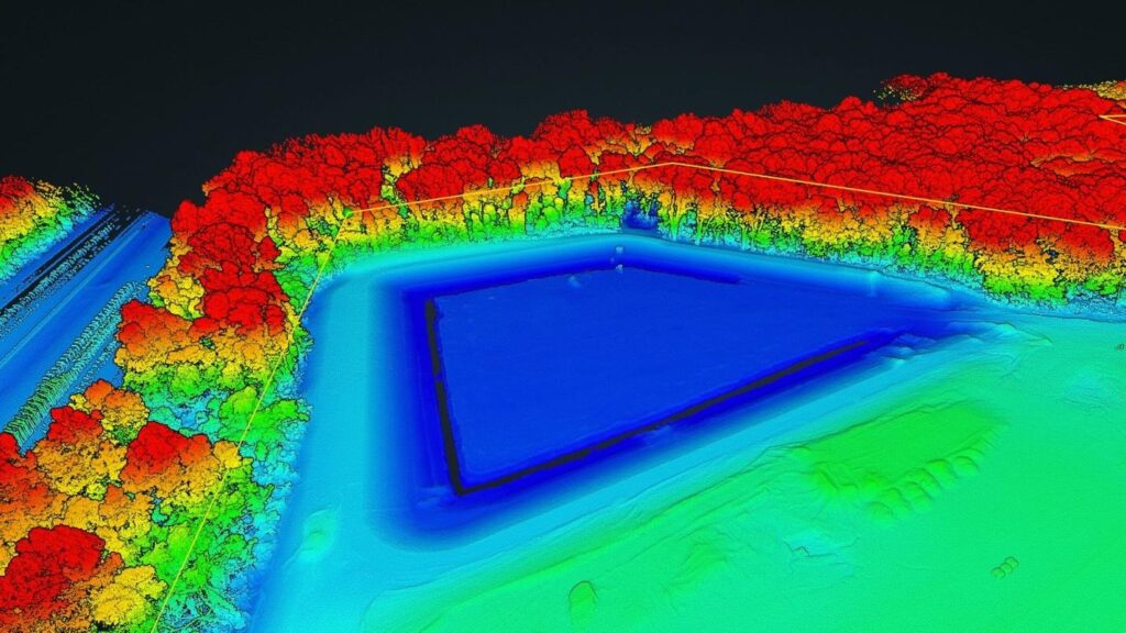
Another game changing technology is Light Detection and Ranging (LiDAR). It functions through the emission of laser pulses and measuring the time of return of the pulses after hitting an object. The outcome is a three dimensional point cloud of extremely detailed terrain, structures and vegetation.
LiDAR may be implemented in several ways:
- Aerial LiDAR using aircraft or drones
- Mobile LiDAR mounted on vehicles
- Terrestrial LiDAR using ground-based scanners
This technology is particularly useful in dense vegetation regions where conventional surveying is not very effective. LiDAR has the ability to penetrate tree tops and show the ground level elevations with amazing clarity.
Unmanned Aerial Systems (Drones)
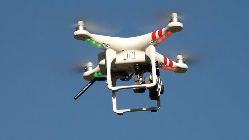
Unmanned Aerial Systems (UAS) or Drones are quickly emerging as a common surveying instrument. Drones also have high-resolution cameras or LiDAR sensors which can take a closer aerial view in a fraction of the time it would take the traditional methods.
Drone surveying is especially useful for:
- Large or inaccessible sites
- Monitoring of construction progress
- Topographic mapping
- Volumetric calculations (stockpiles, excavation)
Drone imagery is processed by licensed operators and certified photogrammetrists into orthomosaics, digital elevation models and 3D surfaces. This speed and precision has turned drones into an essential part of the modern land surveying technology.
Aerial Photogrammetry
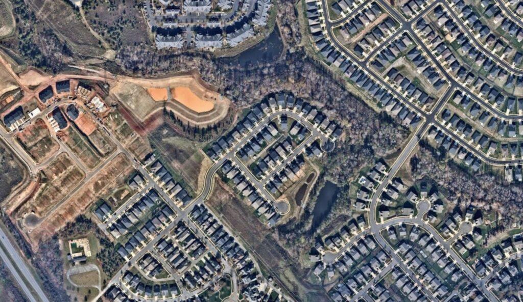
Photogrammetry involves the use of overlapping aerial photographs in order to develop precise measurements and 3 dimensional models. Although the idea is not novel, it has been enhanced by the current software and high-resolution sensors that have contributed to its reliability and accuracy to a significant degree.
When used together with drones or crewed aircraft, photogrammetry enables surveyors to create:
- Detailed site maps
- Contour models
- Elevation data
- Visual documentation for planning and compliance
Photogrammetry, unlike LiDAR, uses visual data and is therefore useful in mapping visible surfaces and structures. Most projects are a mix of the two approaches to give a more detailed space analysis.
Mobile Mapping Systems

Mobile mapping incorporates GNSS, LiDAR, cameras, inertial measurement units on a moving platform, i.e., a vehicle. This method is the best in capturing the data on the road, railways, and urban corridors without disturbing the traffic or closing lanes.
The sensors constantly measure the spatial information as the vehicle moves, which results in precise georeferenced datasets. This technique is common in the transport planning, assets inventories and urban infrastructure evaluations.
Mobile mapping also shows that land surveying technology is changing to fit into the real world where time and safety is paramount.
Cloud-Based Data Processing and GIS Integration
Recording data is not the whole story. New surveying technology focuses on data processing, storage and sharing equally. The cloud based platforms enable survey crews to post field information in real time, work remotely, and combine the findings with Geographic Information Systems (GIS).
GIS integration enables:
- Layered spatial analysis
- Long-term data management
- Cross-disciplinary collaboration
- More intelligent planning and decision making
This digital ecosystem makes sure that the outcomes of the surveys can be used several years after the fieldwork is over.
Why These Technologies Matter
The actual worth of the new land surveying technology is the effect it has. The projects are done in a shorter time, the chances of risks are minimized and the decision-makers are in a better position to understand the conditions of the site before the construction process starts.
Mistakes which previously emerged late in a project are identified early and this saves time and costs. This translates to improved predictability and confidence to the clients. To surveyors, it represents a more technologically advanced, analytical and data-driven profession.
Conclusion
In the future, the process of surveying will be further streamlined with the help of artificial intelligence, machine learning, and real-time data analytics. The only thing that will never change is the presence of the skilled professionals who know the technology and even the land itself. The new tools are not substitutes of expertise: they enhance it.
The new survey technology is a transition from measuring to the overall spatial understanding. With GNSS and LiDAR, drones, and cloud-based GIS, the current technology of land surveying provides accuracy, efficiency, and detail more than ever before. The more complex and data-driven development is, the more these innovations help to make surveying not only relevant, but a crucial part of the built environment formation.