Creating accurate 3D representations of real-world environments has become a priority in fields like construction, urban planning, robotics, and environmental analysis. However, the reality on many projects is far from simple. Teams often deal with uneven accuracy across large sites, noisy or incomplete data, and processing workflows that take far longer than planned. It’s not uncommon to capture huge volumes of scan data, only to discover that converting those raw files into usable 3D models demands significant time and manual effort.
These challenges have prompted professionals to rethink how spatial data is captured and handled from the start. High-density spatial data, especially when produced using a LiDAR 3D scanner, offers a more reliable path forward by enabling consistent, precise capture of complex environments while reducing the friction between data collection and practical use.
Understanding High-Density Spatial Data
High-density spatial data refers to datasets composed of a very large number of precisely measured points that describe the shape and position of objects and surfaces in three-dimensional space. These datasets are most commonly stored as point clouds, where each point represents a specific location and may also include attributes such as reflectivity or color.
What distinguishes high-density data from simpler spatial datasets is resolution. A higher point density means finer geometric detail, which is especially important when modeling environments with irregular surfaces, structural complexity, or subtle elevation changes. When properly captured and processed, dense spatial data forms the foundation for accurate and reliable 3D environment models.
How LiDAR Supports Accurate Environment Capture
How LiDAR Works in Spatial Scanning
LiDAR technology measures distance by emitting laser pulses and recording the time it takes for each pulse to return after striking a surface. By repeating this process millions of times per scan, a LiDAR 3D scanner produces a dense point cloud that reflects the geometry of the surrounding environment. Because the system relies on its own light source, it operates independently of ambient lighting conditions.
Advantages of LiDAR for Large and Complex Spaces
LiDAR is particularly effective for environments that are difficult to capture using image-based methods alone. Its ability to maintain accuracy over longer distances makes it suitable for scanning buildings, infrastructure, terrain, and mixed indoor–outdoor spaces. Consistent point spacing and repeatable measurements help reduce distortion when multiple scans are combined into a single model.
These characteristics make LiDAR a preferred option when accuracy, scale, and reliability are critical requirements.
From Raw Scans to Usable 3D Models
Capturing spatial data is only the first step. Transforming raw point clouds into usable 3D environment models requires a structured workflow that balances automation with informed oversight.
Data Acquisition and Planning
Successful modeling begins before scanning starts. Planning involves defining coverage areas, selecting appropriate scan resolution, and ensuring sufficient overlap between scans. Overlap is essential for aligning multiple datasets accurately, especially in large or segmented environments.
Preprocessing and Data Refinement
Raw point clouds often contain noise caused by reflective surfaces, moving objects, or environmental interference. Preprocessing steps typically include:
- Removing outliers and unwanted points
- Aligning multiple scans into a shared coordinate system
- Normalizing scale and orientation
These steps improve data quality and reduce errors that could propagate into the final model.
Model Reconstruction and Output
Once the data has been cleaned up and properly aligned, point clouds can be turned into surface models or meshes that are easier to work with. Depending on the project, this might mean identifying flat surfaces like walls and floors, rebuilding terrain features, or simplifying complex geometry so it can be used for simulations or visual reviews. The aim isn’t always to capture every tiny detail, but to create a model with just the right level of detail to support the task at hand.
Tools and Product Categories in Spatial Modeling
Rather than relying on a single device or application, accurate environment modeling typically involves a combination of complementary tools. Understanding these categories helps clarify how different technologies fit into the workflow.
| Tool category | Primary function | Typical applications |
| LiDAR scanners | Distance measurement and point capture | Buildings, terrain, infrastructure |
| Structured-light scanners | High-detail surface capture | Interiors, objects, small spaces |
| Point cloud software | Processing and visualization | Registration, filtering, analysis |
| 3D modeling platforms | Model refinement and export | Simulation, planning, visualization |
Some modern scanning systems blend features from multiple categories, offering portability alongside high-resolution spatial capture. These hybrid approaches are increasingly used where flexibility and efficiency matter as much as raw precision.
Key Use Cases Across Industries
Urban Planning and Infrastructure
City planners and engineers use dense spatial data to create 3D models of urban environments. These models support zoning analysis, infrastructure assessment, and long-term development planning by providing a clear, measurable view of existing conditions.
Construction and Facility Management
In construction, accurate environment models help teams compare design intent with as-built conditions. Regular scanning enables progress tracking, clash detection, and documentation without relying solely on manual measurements.
Environmental and Terrain Analysis
High-density spatial data is widely used to analyze terrain, vegetation, and natural features. Accurate elevation models support flood risk assessment, land-use planning, and environmental monitoring over time.
Robotics and Autonomous Systems
Robotic systems depend on precise spatial understanding to navigate safely. Point clouds generated by a LiDAR 3D scanner are often used to build maps for localization, obstacle avoidance, and path planning in both indoor and outdoor settings.
Accuracy Depends on More Than Density
While high point density is valuable, it does not automatically guarantee accurate models. Accuracy depends on several interrelated factors:
- Proper scan planning and coverage
- Sensor calibration and stability
- Quality of alignment and registration
- Appropriate level of model simplification
Neglecting any of these elements can introduce errors, even when using advanced scanning technology. Reliable results come from combining capable tools with disciplined workflows.
Emerging Trends in 3D Environment Modeling
Advances in processing software and computing power are reshaping how spatial data is used. Automated segmentation, machine learning–assisted feature extraction, and near–real-time reconstruction are reducing the time between capture and insight.
Another important trend is multi-sensor integration. Combining LiDAR data with imagery or other sensor inputs can enrich models with additional context, improving both visual quality and analytical value. As these approaches mature, environment modeling is becoming more accessible to smaller teams and new industries.
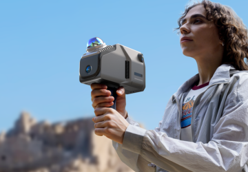
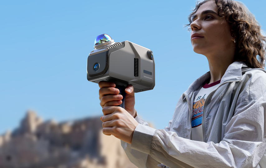
Within this evolving landscape, some hardware platforms are designed to take advantage of these trends at the data capture stage. 3DMakerpro Eagle integrates a high-performance LiDAR system that supports extensive spatial scanning with strong precision and wide coverage angles, using a 360°×59° field of view that enables more comprehensive environment capture in fewer passes, often allowing a full room to be scanned with a single, simple rotation.
Conclusion
Accurate 3D environment models start with more than just advanced tools; they rely on high-quality spatial data, careful planning, and well-structured processing workflows. High-density datasets captured with a LiDAR 3D scanner can help overcome many of the common challenges in large-scale modeling, such as uneven accuracy and inefficient data handling. Still, technology on its own isn’t a complete solution.
The most dependable results come from a clear understanding of how data is captured, refined, and applied in real-world contexts. As the need for precise digital representations continues to grow, these fundamentals will remain critical for professionals working at the intersection of the physical and digital worlds.