
Archaeology has long relied on cutting-edge technology to unravel the mysteries of past civilizations. The groundbreaking Real-Time Kinematic (RTK) Global Navigation Satellite System (GNSS) technology has ushered in a new era of precise and efficient archaeological practices. With its remarkable accuracy at the centimeter-level for positioning and navigation, this advanced technology has revolutionized archaeological excavations and mapping. This article explores the transformative role of RTK GNSS technology in archaeology, showcasing its profound impact on our comprehension of history and its promising potential for future discoveries.
The initial step in any archaeological endeavor is the discovery and identification of potential archaeological sites. Traditionally, this process has been laborious and time-consuming, relying on physical surveying methods or aerial photographs. However, the introduction of RTK GNSS technology has completely changed this practice.
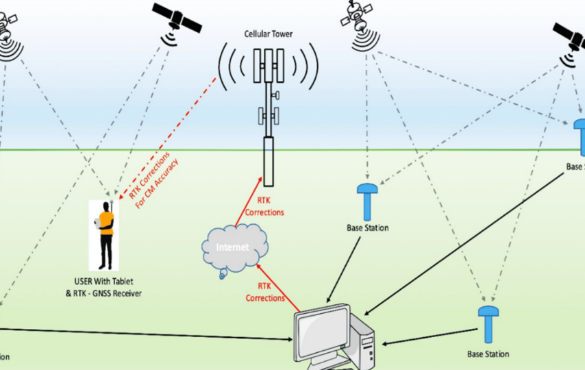
RTK GNSS receivers, with their ability to provide highly precise location data, have become indispensable tools for archaeologists working in the field. By leveraging RTK GNSS technology, archaeologists can accurately determine exact locations on the Earth’s surface, down to the centimeter.
This capability empowers professionals to create highly accurate georeferenced maps of potential archaeological sites, significantly enhancing planning and execution of subsequent excavation work. Moreover, RTK GNSS technology aids archaeologists in identifying subtle landscape changes that could indicate the presence of archaeological features like earthworks or buried structures. By providing detailed and precise topographical maps of the area, RTK GNSS allows for targeted and efficient exploration of potential sites.
Consider an archaeologist tasked with surveying a large area of land. Utilizing a multi-band RTK GNSS receiver, they can swiftly and precisely map the area, identify points of interest, and strategically plan excavation procedures to an unprecedented level of accuracy.
In this way, RTK GNSS technology not only streamlines the process of site discovery but also amplifies the possibilities for remarkable archaeological findings.
RTK GNSS in Archaeological Excavations
Once an archaeological site is identified, the meticulous process of excavation commences. This phase requires precision and careful planning, with the aid of highly accurate RTK GNSS technology.
One of the primary applications of RTK GNSS receivers in archaeological excavations involves establishing a grid. Before any digging occurs, archaeologists divide the site into smaller, manageable units using a grid system. This enables precise recording of artifact locations, a critical component of archaeological research. The centimeter-level accuracy provided by RTK GNSS technology ensures the precise placement of these grid systems, laying a solid foundation for excavation work.
Furthermore, RTK GNSS receivers play a vital role in the creation of an initial site plan, an indispensable tool in any excavation project. These plans present a detailed map of the site, including structures, features, and designated excavation areas. Through the utilization of RTK GNSS technology, these site plans can be crafted with exceptional accuracy, guaranteeing accurate targeting of all excavation work.
In the field, the advantage of lightweight and portable receivers becomes apparent, offering flexibility and ease of use without compromising on accuracy. For instance, their ability to connect with external devices and compatibility with correction services streamlines data collection and sharing, elevating the efficiency of the excavation process.
Furthermore, advanced receivers can function in various modes such as RTK and PPK (post processed kinematic), providing archaeologists with flexibility tailored to their specific project requirements, whether it be real-time results or post-processed data for further analysis.
By integrating RTK GNSS technology into their excavation processes, archaeologists can conduct their work with an unparalleled level of precision and efficacy.
The Future of RTK GNSS Technology in Archaeology
Archaeology is undergoing a transformative shift, thanks to the tremendous impact of RTK GNSS technology. Looking ahead, the potential for this technology to revolutionize archaeological practices is truly remarkable.
As GNSS technology continues to advance, we can anticipate unprecedented levels of precision and efficiency in the years to come. Exciting possibilities lie on the horizon, including the development of more robust receivers capable of harnessing signals from a greater number of satellites. This will undoubtedly enhance the reliability and accuracy of positioning data, paving the way for groundbreaking discoveries.
Furthermore, as technology becomes increasingly intertwined with our daily lives, the adoption of RTK GNSS in the field of archaeology is set to expand dramatically. Its applications will extend beyond mere site discovery and excavation, encompassing artifact analysis, data management, and even virtual reality reconstructions of archaeological wonders.
In this dynamic era, the future of archaeology holds boundless potential, thanks to the distinct and original contributions of RTK GNSS technology.
What’s Ahead
As RTK GNSS technology becomes increasingly accessible and user-friendly, it also holds the potential to contribute significantly to community archaeology projects and educational programs. By embracing this technology, a broader audience can actively participate in archaeological practices, fostering a deeper understanding and appreciation of our collective heritage.
In conclusion, the future of RTK GNSS technology in archaeology appears incredibly promising. As we continue to delve into our past with the aid of this advanced technology, the possibilities for extraordinary discoveries are boundless.